
This map shows where this project fits in with the larger proposed Bus Rapid Transit system.
Project overview
This multi-phase project is part of the Halifax Regional Municipality’s Integrated Mobility Plan (IMP) and Rapid Transit Strategy, designed to meet immediate transportation needs while preparing the Halifax region for future growth.
This project also supports the increased residential density already approved for the Robie Street corridor under the Centre Plan, enabling more people to live near high-frequency transit and maximizing the benefits of this major infrastructure investment.
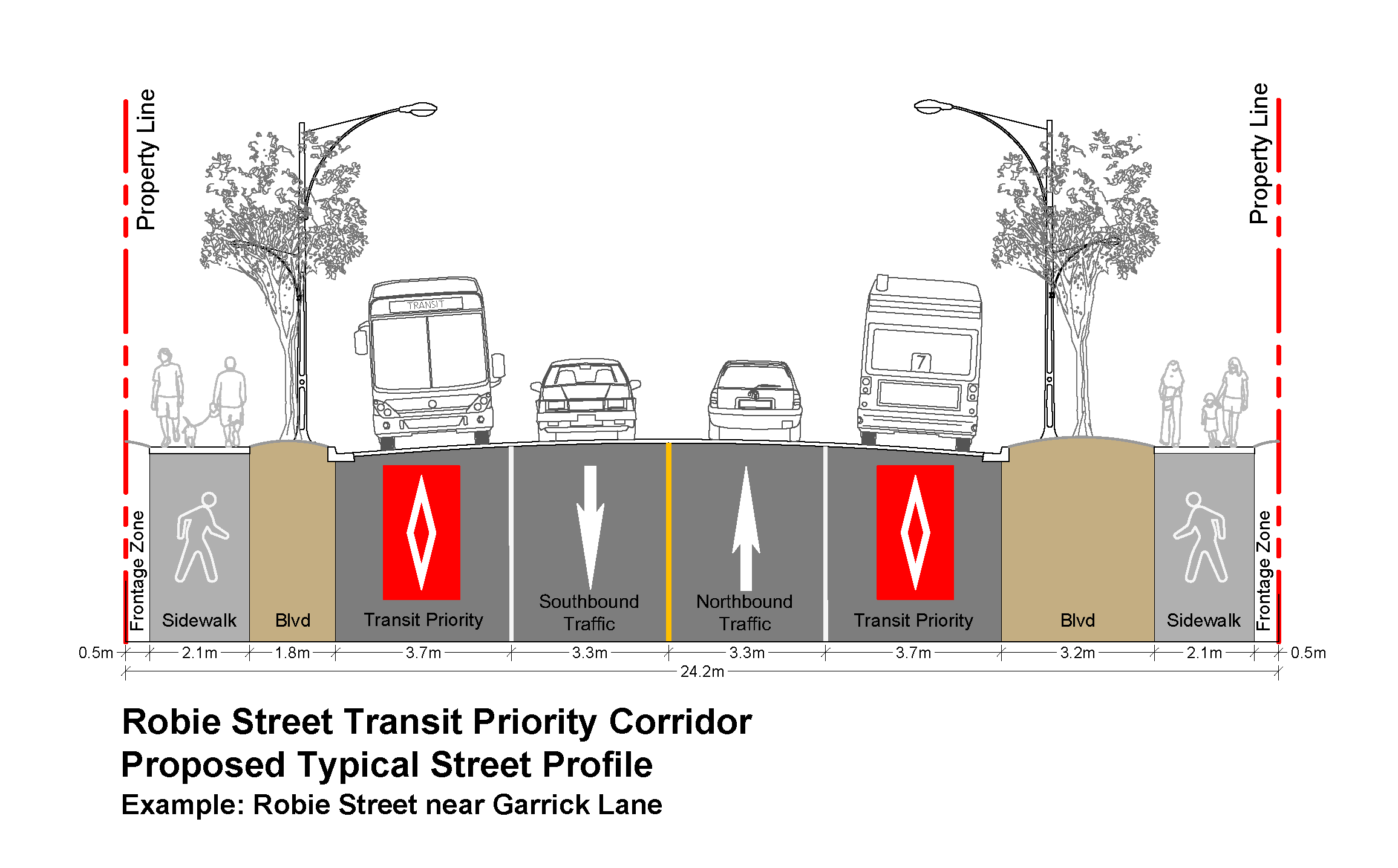
Cross-section diagram of Robie Street between Almon and Cunard streets.
The Robie Street corridor is a vital north-south link on the peninsula and is expected to serve two of four proposed Bus Rapid Transit lines.
- In the short term, the project will introduce dedicated transit lanes to improve reliability for existing Halifax Transit routes.
- Longer term, the corridor is being designed to support higher-order transit, including Bus Rapid Transit and potentially Light Rail Transit further in the future.
By acting now and planning ahead, this project ensures the municipality is building the infrastructure today that will support sustainable, high-capacity transit solutions for decades to come. More details are available in the addressing current and future transportation needs section below.
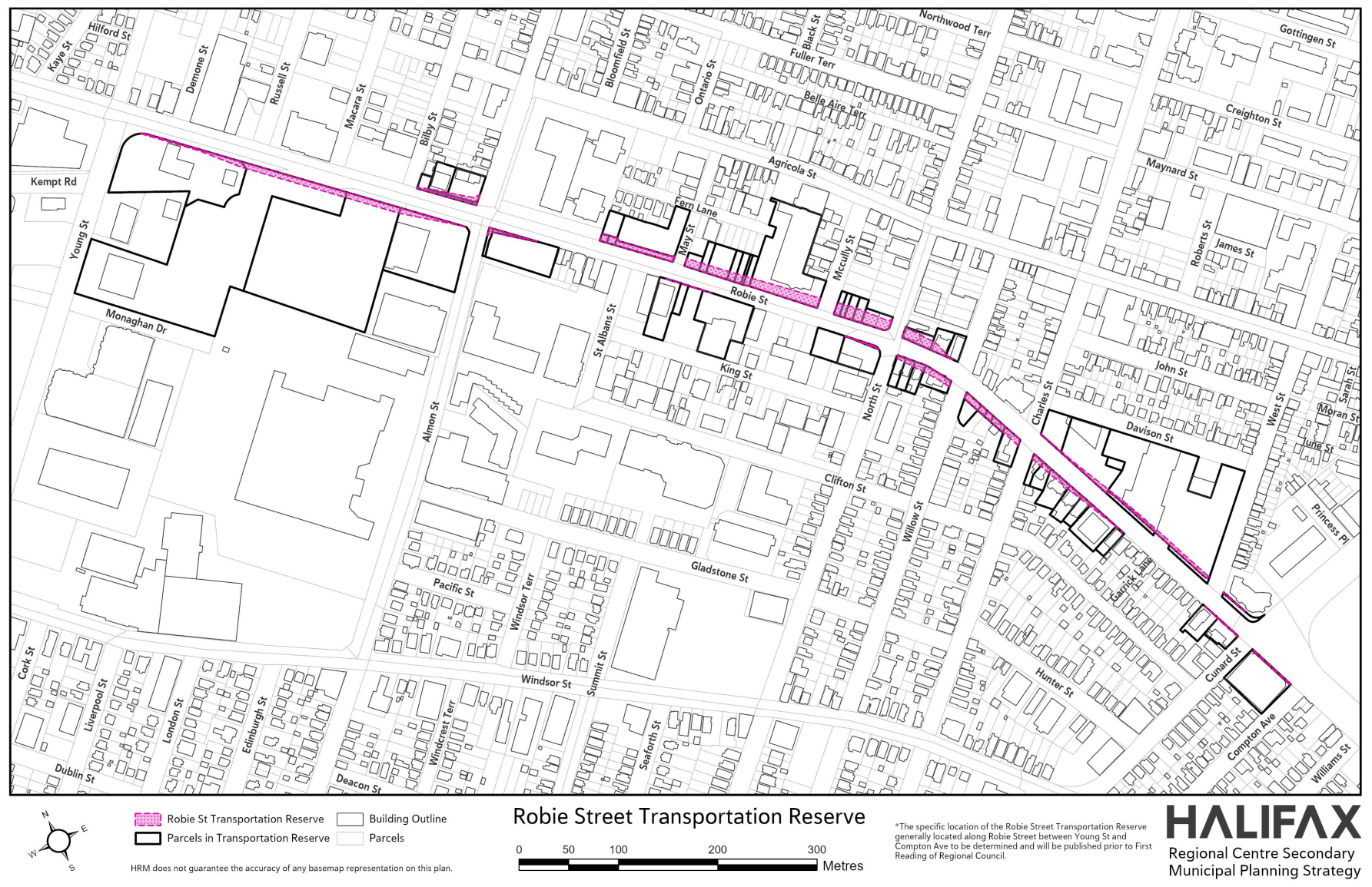
Robie Street Transportation Reserve
Current project status
Last updated on May 15, 2025
Transportation reserve land requirements and property acquisition
To support the development of a safer, more efficient and connected Robie Street corridor, the municipality is acquiring land within the Robie Street Transportation Reserve. Approved by Regional Council in October 2021 as part of Centre Plan Package B, the reserve establishes the space required to introduce dedicated transit lanes and enable future enhancements for pedestrians, cyclists, transit users, and drivers.
Following Council approval, property owners within the reserve area were notified that land acquisitions would occur over a five-year period. The municipality is currently in the process of securing 33 properties (or portions of properties) between Young and Cunard streets. As of April 2025, approximately half of these properties are under agreement or have already been acquired. The remainder are expected to be secured by November 2026.
Acquiring land early is a critical step in reducing redevelopment risks and ensuring that future infrastructure investments can proceed on schedule. These efforts reflect the municipality’s commitment to building a more sustainable, inclusive, and transit-oriented region.
The municipality recognizes that many properties along this corridor are leased commercial or residential spaces and is approaching the acquisition process with empathy and awareness of the region’s ongoing housing challenges. As is typical during the sale of a leased property, it is the property owner’s responsibility to communicate with tenants.
The land acquisition process involves clear communication with owners, valuation based on fair market principles, and flexibility in timing wherever possible. These negotiations are guided by Council direction and are essential to delivering the kind of modern, people-focused transportation corridor envisioned through the Integrated Mobility Plan and Rapid Transit Strategy.
Supporting more housing through increased density along priority transit routes
Of the remaining properties to be acquired, seven include mixed-use or residential buildings that will need to be removed before construction begins. These acquisitions are taking place in an area already rezoned through the Centre Plan to support greater residential density and a mix of land uses.
This redevelopment will make better use of under-utilized land for new housing, contributing to a significant increase in residential units along the Robie Street corridor. It supports the broader goal of building complete communities—enabling more people to live near high-frequency transit, jobs, and services—maximizing the benefits of this major infrastructure investment.
This work also aligns with the ongoing Young District Infrastructure Plan, which is assessing future infrastructure needs in the area beyond transit, including improvements to active transportation and utilities.
Addressing current and future transportation needs
The Robie Street/Young Street Transit Priority Corridor is designed to meet both the current and future needs of Halifax’s evolving transportation network.
- Addressing near term needs (Present to 2032)
In the near term, the project introduces dedicated curbside transit lanes through road widening in key segments of the corridor, improving the reliability and speed of existing Halifax Transit services.
These upgrades are essential for addressing congestion and enhancing service for the multiple transit routes that rely on this corridor today.
- Preparing for Bus Rapid Transit (2032 and beyond)
Looking ahead, the project is being designed to accommodate Bus Rapid Transit, a higher order transit service proposed in the municipality’s Rapid Transit Strategy that will provide a network of high frequency transit lines that run primarily in dedicated bus lanes.
These improvements lay the groundwork for future Bus Rapid Transit implementation, including potential features such as centre median bus lanes, off-board fare collection and enhanced Bus Rapid Transit stations.
Centre median bus lanes, which are proposed as a future configuration, provide a higher level of transit priority by minimizing interference from turning vehicles and general traffic.
- Designed with the potential for light rail in mind
The planned design not only supports more efficient Bus Rapid Transit service but also positions the corridor for a potential future conversion to Light Rail Transit, should ridership levels and population growth support such a transition.
This phased approach ensures that immediate transit needs are addressed while proactively planning for a scalable, high-capacity and low-emission transit system. The corridor’s initial role (2020–2030) as a reliable route for conventional transit will evolve post-2030 into a vital spine of the regional Bus Rapid Transit network—with flexibility to support potential Light Rail Transit infrastructure in the long term.
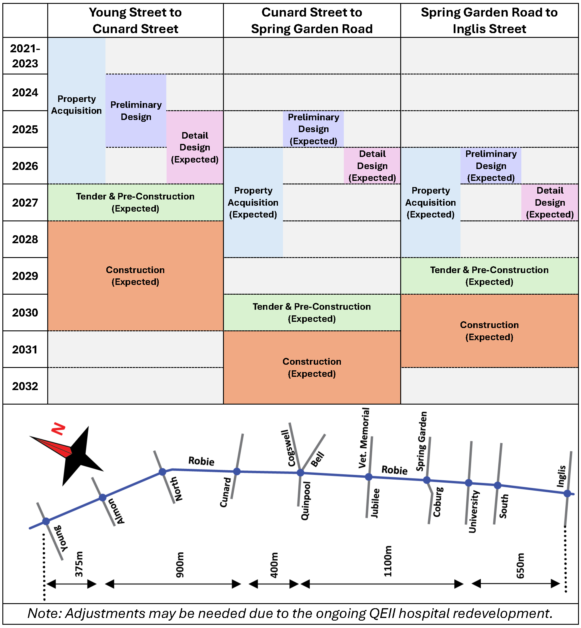
Timeline
The timeline below outlines the current and future stages of this project based on direction from Regional Council and detailed in municipal staff reports.
- Robie Street - Young Street to Cunard Street
- Property acquisition: 2021 to 2026
- Preliminary design: 2024 to 2025
- Detail design (expected): 2025 to 2026
- Tender & Pre-Construction (expected): 2027
- Construction (expected): 2028 to 2030
- Robie Street - Cunard Street to Spring Garden Road
- Preliminary design (expected): 2025
- Property acquisition (expected): 2026 to 2028
- Detail design (expected): 2026
- Tender & Pre-Construction (expected): 2030
- Construction (expected): 2031-2032*
*Adjustments may be needed due to the ongoing QEII hospital redevelopment.
- Robie Street - Spring Garden Road to Inglis Street
- Property acquisition (expected): 2026 to 2028
- Preliminary design (expected): 2026
- Detail design (expected): 2027
- Tender & Pre-Construction (expected): 2029
- Construction (expected): 2030-2031
Project history
This project is driven by Regional Council-approved long-term plans and strategies. Public consultation and engagement have been key to the development of these strategies, plans, and the individual projects that come from them.
- April 2025 – Project update report presented to Transportation Standing Committee
On March 27, 2025, the Transportation Standing Committee requested a staff information report on the Robie Street Transit Priority Corridor project, outlining the project’s origin, design options considered, past Council direction, community engagement, project status, projected implementation timeline, current budget commitments and project risks.
On April 24, 2025, staff presented the requested project update to the Transportation Standing Committee. The Committee voted to forward the report to Regional Council for information and directed the Chief Administrative Officer to provide a supplemental report on the North Street to Cunard Street section. This follow-up report is to include estimated costs, projected time savings, rationale for the selected design model over alternatives such as transit priority signals and reversible lanes, and potential impacts on trees and buildings.
Related links:
- December 2024 – Project update
In July 2019, Regional Council approved municipal staff’s recommendation to further investigate the right of way requirements necessary to accommodate continuous curbside transit lanes along the Robie Street / Young Street corridor in both directions, as well as an option that would add continuous median transit lanes along Robie Street in both directions.
The project is currently proceeding on two fronts – preliminary design and land needs:
- Preliminary design: Preliminary Design for Robie Street is currently underway from Young Street to Cunard Street.
- Land needs: The current road right-of-way is too narrow to accommodate continuous transit priority lanes in both directions and appropriate pedestrian facilities. Land needs were established by functional design and reserved for municipal use by the Robie Street Transportation Reserve, under Centre Plan.
- June 2024 – Housing Accelerator Fund
To accelerate housing supply, Regional Council approved comprehensive zoning changes to increase density and remove barriers to new housing. These changes enabled increased density along the Robie Street corridor, including increased floor area ratio, and increased heights.
Related links:
- October 2021 – Regional Council approve the Robie Street Transportation Reserve
Regional Council approved the Robie Street Transportation Reserve as part of the Centre Plan Package B on October 26, 2021. This reserve was established to support future transit infrastructure along Robie Street, aligning with the IMP and the Rapid Transit Strategy.
Related links:
- October 2020 – Phase 1 complete
Phase 1 was completed in October 2020. This phase added bus lanes to sections of Robie Street and Young Street as outlined below.
Robie Street:- Quinpool Road to Cunard Street: both directions
- Cunard Street to Almon Street: northbound (outbound) only
- Almon Street to Young Street: both directions
The Robie Street bus lane is available for the exclusive use of transit vehicles Monday to Friday from 6 a.m. to 6 p.m. Outside of these times, some locations allow for parking and/or loading.
Young Street:
- Robie Street to Windsor Street: westbound (outbound) only
- June 2020 – Regional Council award Phase 1 project tender
Related links:
- May 2020 – Regional Council approve Rapid Transit Strategy
The Rapid Transit Strategy builds on the vision of the IMP, aiming to improve sustainable transportation options and better support population growth. It invests in high-quality transit service and infrastructure, a key to improving residents’ mobility and building more sustainable, affordable, and equitable communities.
Rapid Transit is fast and reliable transit service that typically operates in a dedicated right of way and can shape land use patterns by attracting development near stations and terminals. It gets you where you want to go, when you want to go, faster and more frequently—seven days a week.
The strategy establishes Transit priority corridor networks, proposes new ferry service, and sets a direction for land use policy to align with Rapid Transit. Learn more about the Rapid Transit Strategy here.
Related links:
- November 2019 – Centre Plan Package A
Centre Plan Package A came into effect, which enabled new density along the Robie Street corridor, including new Centre (CEN-2) and Corridor Zones.
Related links:
- July 2019 – Regional Council approve project detailed design
Related links:
- June 2019 – Transportation Standing Committee approve project detailed design
Related links:
- February 2018 – Project public consultation and engagement
Residents were invited to take part in the Robie and Young Transit Corridors Open House in February 2018.
The municipality presented potential ways to improve the movement of buses on Robie
and Young streets to make transit service faster and more reliable. It was acknowledged that these preliminary design concepts being considered may impact private property, utilities, trees, parking, loading and traffic operation along the corridor.
The following materials were presented:
- December 2017 - Regional Council approve IMP
In 2017, Regional Council endorsed a new vision for moving people and goods. The IMP guides investment in active transportation, transit, transportation demand management, goods movement and the roadway network in Halifax.
Related links:
- 2016 and 2017 – IMP public consultation and engagement
Throughout the planning process for the IMP, the municipality conducted three rounds of engagement, with a broad reach throughout the region. To share back insights from each round of engagement and summarize the feedback we received, staff compiled three What We Heard reports. For more information about the public engagement for the IMP, please visit Engage Halifax.
Related links:
Learn more about transit priority lanes
Common questions
- Is the municipality purchasing land as part of this project?
Yes. The municipality is in the process of purchasing 33 properties (or portions of properties) as part of the Robie Street Transportation Reserve, approved by Regional Council in 2021.
This land is required to support dedicated Halifax Transit lanes now, and to enable future enhancements for the proposed Bus Rapid Transit system and potentially light rail transit further in the future.
As of April 2025, approximately half of the 33 properties are under agreement or have been acquired. The rest are expected to be secured before November 2026.
- Were property owners notified that the municipality would be purchasing land as part of this project?
Yes. Following Regional Council’s approval of the Robie Street Transportation Reserve in 2021, property owners within the designated area were notified that acquisitions would occur over a five-year period.
- Who is responsible for notifying tenants about property sales?
As is typical during the sale of leased property, it is the property owner's responsibility to communicate with tenants.
Following Regional Council’s approval of the Robie Street Transportation Reserve in 2021, property owners within the designated area were notified that acquisitions would occur over a five-year period.
- Why is transit priority needed here and what are their long-term benefits?
Served by eight routes and more than 40 buses during the morning and afternoon peak hours, the Robie/Young Street Transit Priority Corridor project is a key component of the Moving Forward Together Plan, the Integrated Mobility Plan (IMP) and the Rapid Transit Strategy.
In the short term, dedicated bus lanes help Halifax Transit provide faster, more reliable service by bypassing traffic congestion.
Long term, this corridor is being designed to accommodate Bus Rapid Transit—a higher-order service that may include centre median lanes, off-board fare collection and enhanced stations.
This investment prepares the corridor for potential future conversion to Light Rail Transit, should ridership and population growth support it.
- Why Robie Street?
Robie Street is a major arterial road connecting hospitals, universities, downtown, and key recreational, residential and commercial areas. It is identified in the municipality’s Rapid Transit Strategy as a central spine of the proposed Bus Rapid Transit network, serving two of the four proposed future lines.
- Why Young Street?
Young Street connects Bayers Road and Robie Street and supports rapid growth in the surrounding area. It forms an important east-west link in the broader Bus Rapid Transit network proposed in the municipality’s Rapid Transit Strategy.
- Could other options be used to avoid widening Robie Street, such as reversible lanes or transit priority signals?
The municipality has carefully considered alternative options to provide transit priority on Robie Street without widening the corridor. These included measures such as reversible lanes and transit signal priority. While these tools can offer benefits in some contexts, they would not provide the level of service or reliability required to support BRT along this corridor.
- A reversible lane is a traffic lane that changes direction depending on the time of day—for example, carrying traffic southbound in the morning and northbound in the afternoon. This approach can work in areas with strong, one-directional rush hour traffic, such as the Macdonald Bridge, Herring Cove Road and Chebucto Road in Halifax. However, Robie Street doesn’t have this kind of pattern—northbound traffic is consistently heavier throughout most of the day. As a result, a reversible lane wouldn’t be effective. Additionally, since BRT service requires dedicated lanes in both directions all day, this type of configuration would not meet long-term transit needs.
- Transit signal priority tools—like queue jump lanes and green light extensions for buses—are already in use in the Halifax region and will continue to support transit service. But these tools are most effective at intersections. Without dedicated bus lanes between intersections, buses can still get stuck in regular traffic. That’s why continuous transit lanes are needed to make BRT reliable and fast along the entire corridor.
- A reversible lane is a traffic lane that changes direction depending on the time of day—for example, carrying traffic southbound in the morning and northbound in the afternoon. This approach can work in areas with strong, one-directional rush hour traffic, such as the Macdonald Bridge, Herring Cove Road and Chebucto Road in Halifax. However, Robie Street doesn’t have this kind of pattern—northbound traffic is consistently heavier throughout most of the day. As a result, a reversible lane wouldn’t be effective. Additionally, since BRT service requires dedicated lanes in both directions all day, this type of configuration would not meet long-term transit needs.
- Why can’t bus-only lanes be limited to peak hours?
Limiting bus lanes to peak hours only (such as 7 to 9 a.m. and 4 to 6 p.m.) may seem like a reasonable compromise, but it doesn’t meet the needs of reliable, all-day transit service.
Full-time transit lanes improve speed and reliability throughout the day, making transit a more attractive option for more people. This is essential for supporting future BRT service on Robie Street.
- How will the final design balance transit needs with impacts to other road users?
The design process includes traffic modelling, safety analysis, and public engagement to ensure the needs of all users are considered—drivers, cyclists, pedestrians and transit riders. The goal is to prioritize sustainable transportation while maintaining access and safety for everyone. By acquiring land in advance and carefully phasing the project, the municipality is working to reduce disruption and deliver long-term improvements.
- How will this project impact pedestrians?
Part of the Phase 2 upgrades to the Robie-Young Transit Priority Corridor involves bringing the pedestrian infrastructure on the corridor up to a level appropriate to support the current and future growth in the area. Wider sidewalks, better separation between pedestrians and vehicles and intersection improvements will contribute to a safer, more comfortable neighborhood for pedestrians.
- How will the project impact cyclists?
These upgrades will not add dedicated bike infrastructure to the Robie Street corridor due to width constraints. Cyclists are permitted to use transit lanes where no dedicated bicycle facilities exist. However, current and planned north–south bicycle facilities on nearby parallel streets will continue to provide alternate options for people biking through the area.
- How will the project impact trees?
The north section of this project (Young Street between Windsor and Robie streets, and Robie Street between Young and Cunard streets), 20 young trees, 33 mature trees and seven very mature trees will be removed by this project. Many of the existing street trees in this area show signs of significant stress and stunted growth. Additionally, 19 stumps or standing dead trees were identified in this area.
The project design includes 120 new trees, for a net increase of 80 trees. It also includes wider boulevards which will allow for healthier trees in the long term. As the Robie Street project matures, it will provide a major improvement to the urban forest and support the goals of the Urban Forest Management Plan.
Any tree impacts south of Cunard Street will be assessed during the next design phases. In general, tree impacts are expected to be lower due to the greater available space within the existing roadway.
- What are the environmental and climate benefits of this project?
This project is aligned with municipality’s climate goals:
- Lower vehicle emissions: Dedicated lanes and more reliable transit reduce congestion and idling.
- Higher ridership: A full bus replaces dozens of cars, significantly lowering emissions per person.
- Healthier tree canopy: The project design includes 120 new trees, for a net increase of 80 trees. It also includes wider boulevards to support their growth.
- Cleaner air and healthier communities: More people using public transit results in less air pollution and improved public health.
- Long-term sustainability: Supporting mode shift and Bus Rapid Transit readiness is a key strategy for reducing carbon emissions across the region.
- What are the next phases of this project?
The corridor upgrades are part of a phased approach.
In the near term, the project introduces curbside transit lanes between Young Street and Cunard Street.
Over the next several years, the corridor will be prepared for proposed centre median Bus Rapid Transit lanes and enhanced station amenities. These improvements set the foundation for future Bus Rapid Transit service and allow for the potential conversion to Light Rail Transit, as transit demand increase further in the future.
Project contact
Call 311 or email contactus@311.halifax.ca.